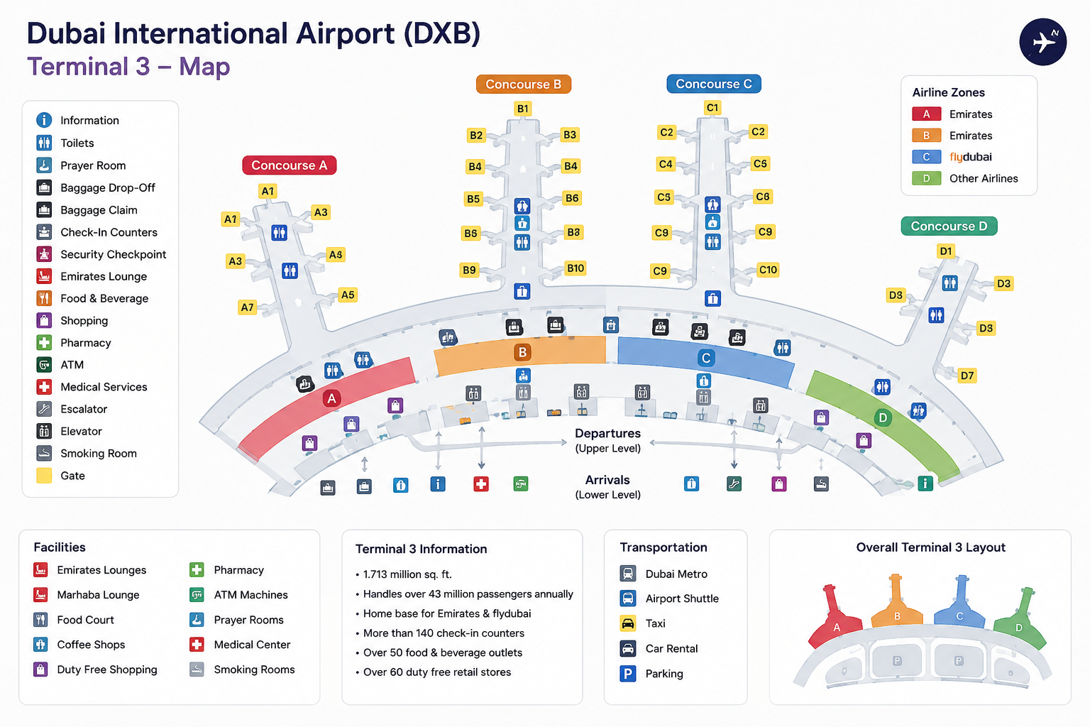
Large airports can be confusing, especially when you are visiting for the first time or have a short connection between flights. With multiple terminals, concourses, security checkpoints, gates, lounges, restaurants, shops, and transportation areas, knowing where to go before you arrive can save valuable time.
Airport terminal maps make airport navigation easier by showing the layout of terminals and helping travelers locate important facilities. Many modern airport maps are interactive and allow passengers to search for gates, restaurants, security checkpoints, shops, services, and other locations. Toronto Pearson, for example, provides interactive maps that can show facilities from the curb to the gate and offer step-by-step directions.
Read More:Airline Carry-On Baggage Rules
What Are Airport Terminal Maps?
An airport terminal map is a visual guide showing the layout of an airport terminal or group of terminals.
A typical map may show:
- Terminal buildings
- Departure and arrival areas
- Check-in counters
- Security checkpoints
- Boarding gates
- Immigration and customs
- Baggage claim
- Airport lounges
- Restaurants and cafés
- Shops
- Restrooms
- Parking areas
- Ground transportation
- Airport trains and shuttles
Some airports provide separate maps for different floors because large terminals can have several levels. Brisbane Airport, for example, provides downloadable maps for different levels of both its domestic and international terminals.
Why Are Airport Maps Important?
Airport navigation can become stressful when you don’t know how far your gate is from security or whether you need to change terminals.
An airport terminal map gives you a visual overview before you start walking.
It can help you answer important questions such as:
- Where is my departure terminal?
- Which gate do I need?
- Where is security?
- Is my gate in another concourse?
- Where can I find an airport lounge?
- Where are restaurants and shops?
- How do I get to baggage claim?
- Where is the airport train or shuttle?
- Where can I find parking?
Having this information in advance is especially useful for travelers with short connections.
Airport Terminal Maps and Gate Maps
One of the most important features of airport maps is the airport gate map.
Gate numbers are normally organized into groups or concourses. For example, an airport may have gates labeled A1–A20 in one area and B1–B30 in another.
However, every airport uses its own system. Some airports have multiple terminals with separate gate ranges, while others have one large terminal divided into concourses.
Airportmaps, for example, provides terminal and gate information together with locations for services such as restaurants, transportation, parking, and security.
Before walking to your gate, check the map to understand:
- Your current location
- Your terminal
- Your concourse
- Your gate number
- The walking route
- Any transportation required
Interactive Airport Maps
Traditional PDF maps are useful, but interactive airport maps can make navigation even easier.
Interactive maps may allow travelers to search for a particular location and receive directions. Some can show restaurants, retail stores, lounges, charging stations, restrooms, and security checkpoints.
This is particularly useful at large international airports where walking from one area to another can take considerable time.
Instead of searching through a large static map, you can simply search for your gate or desired facility.
How to Find Your Airport Terminal
Your departure terminal is normally shown on your airline booking, boarding pass, or airport departure information.
However, terminal assignments can sometimes change. Airlines may also use different terminals depending on the destination or flight.
For this reason, check the latest information before leaving for the airport.
If you’re taking a connecting flight, don’t automatically assume that your next flight will depart from the same terminal where you arrived.
Some airports require passengers to use:
- Airport trains
- Shuttle buses
- Automated people movers
- Walking tunnels
- Transfer corridors
A terminal map can help you understand the connection before you start moving through the airport.
Airport Security Checkpoint Maps
Security checkpoints are another important feature of airport terminal maps.
A map can help you identify where security is located relative to check-in counters and departure gates.
At some airports, passengers can choose between multiple security checkpoints. In other airports, the checkpoint may be assigned according to the terminal or concourse.
Knowing the location of security before arriving can help you plan your route and avoid unnecessary walking.
Remember that security procedures and checkpoint availability can change, so always follow the airport’s current signs and instructions.
Finding Airport Lounges on a Map
If you have airport lounge access, a terminal map can help you locate your lounge quickly.
Airport lounges may be located:
- Near specific gates
- On another terminal level
- Inside a particular concourse
- After security
- Near international departure areas
This is important because not every lounge is accessible from every part of an airport.
If you have a short layover, check the lounge location before leaving your arrival gate. This helps you estimate how much time you have to relax before returning to your departure gate.
Finding Restaurants and Shops
Airport maps are also useful for finding airport restaurants and shops.
Instead of walking around the entire terminal looking for food, you can use a map to locate cafés, restaurants, food courts, duty-free stores, pharmacies, convenience stores, and other services.
Many airports organize these facilities by terminal level and security area.
This can be particularly useful during long layovers when you want to find food without traveling too far from your gate.
Airport Parking and Transportation Maps
Airport maps aren’t limited to terminal interiors.
Many airports also provide maps showing:
- Short-term parking
- Long-term parking
- Rental car facilities
- Taxi areas
- Ride-share pickup zones
- Bus stops
- Train stations
- Airport shuttles
- Hotel transportation
These maps can help you plan your journey from the moment you arrive at the airport.
For example, a traveler arriving by train can use the transportation map to identify the terminal entrance, while someone driving can find the correct parking area before reaching the airport.
Downloadable PDF Airport Maps
A downloadable airport map can be useful if you expect limited internet access.
Many airports provide PDF maps that travelers can save to their phones or print before traveling.
Static maps are especially useful when:
- Your phone battery is low
- Wi-Fi is unavailable
- Mobile data is expensive
- You’re traveling internationally
- You want a quick offline reference
For complicated airports, consider downloading the map before leaving home.
Airport Maps for Connecting Flights
Airport terminal maps are particularly valuable during international connections.
If your connection requires a terminal change, look at the airport map before your trip and identify the route from your arrival gate to your departure gate.
You may need to pass through additional security, immigration, or customs depending on your itinerary.
Also remember that your departure gate can change. Your boarding pass may show an initial gate, but airport information screens and your airline’s latest updates should be checked during the journey.
Tips for Using Airport Terminal Maps
Check the Map Before Your Flight
Review the airport layout before traveling, especially if it is your first visit.
Save an Offline Copy
Download a PDF or screenshot in case you lose internet access.
Locate Your Gate First
Once you know your gate, you can identify nearby lounges, restaurants, and restrooms.
Check Terminal Connections
Find out whether you need a shuttle, train, or people mover to reach another terminal.
Allow Extra Walking Time
Large airports can require significant walking. Don’t assume that two gates that look close on a map are only a few minutes apart.
Recheck Your Gate
Gate assignments can change. Always confirm your latest gate on airport information screens or through your airline.
Best Airport Terminal Maps for Travelers
The best airport map is usually the one provided directly by the airport you’re using because it is most likely to reflect the latest terminal layout.
Many major airports now offer interactive and downloadable maps. Toronto Pearson provides interactive maps and floor-specific maps, while Brisbane Airport provides maps for different terminal levels.
Third-party airport map services can also be useful for quickly comparing terminal layouts across different airports.
However, travelers should use official airport information for important last-minute details such as gate changes, security procedures, and terminal closures.
Final Thoughts
Airport terminal maps are one of the easiest ways to make airport navigation less stressful. They allow travelers to understand terminal layouts, find gates, locate security checkpoints, discover lounges and restaurants, and plan transportation between different areas.
Whether you’re traveling through a small regional airport or a huge international hub, checking an airport terminal map before your journey can save time and reduce confusion.
For your next flight, find the airport’s official map, locate your terminal and gate, check the route between important areas, and save a copy for offline use. A few minutes of preparation can make your entire airport experience smoother and more comfortable.